Greenstone/Caples & Routeburn
Here's the full story...!
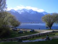
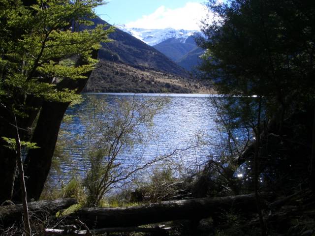
I set off on Tuesday morning, heading for Fjordlands with a few maps printed out and a general idea of some tracks which I could do (options were limited due to the winter weather which has closed many parts of some tramps). Although I’d planned on going to Te Anau and then probably heading up to the Hollyford Track, I changed my mind after reaching Queenstown and decided to start at the Glenorchy side and work my way over. That way I could check current conditions with DOC Glenorchy in the morning and still be on a track soon afterwards, instead of adding four hours of extra driving into the journey. After sleeping in the car (well, kind of), I signed in my intentions (a bit vague at this point) and drove to Kinloch, a beautiful area across Lake Wakatipu. A rough track leads from there to Greenstone car park where the Greenstone and Caples tracks begin.
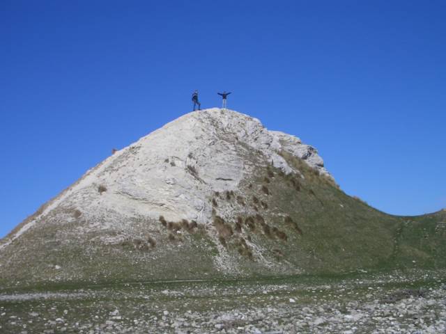
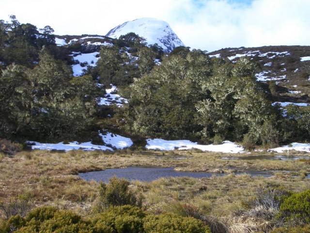
 I followed the Caples track to Howden Hut the first day, a fantastic track with loads of variety. I definitely like the open valleys or at least being on the outskirts of a forest following rivers rather than being stuck beneath a bushline all day.
  Not to sound like a broken record, but the weather was amazing again, it’s a pity this has to end sometime! I managed to smack my knee on a fallen tree which was kind of painful but keeping moving was the only solution…I was slightly fearful it would stiffen up if I stopped for a rest, and there wasn’t really time for that anyway! After Upper McKellar Hut the track climbs steeply for a while to McKellar Saddle, followed by an extremely sharp and interesting descent, especially with fallen trees and rocks blocking much of the track!


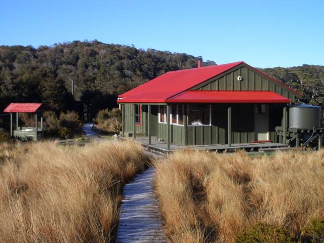
After skirting around the side of Lake McKerrow it ends up joining the Western end of the Routerburn Track at Howden Hut. Unfortunately I couldn’t get a fire going that night because there was hardly any dry firewood or coal in the bucket, but at least it hadn’t rained so I was pretty dry and not too cold.
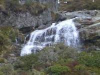
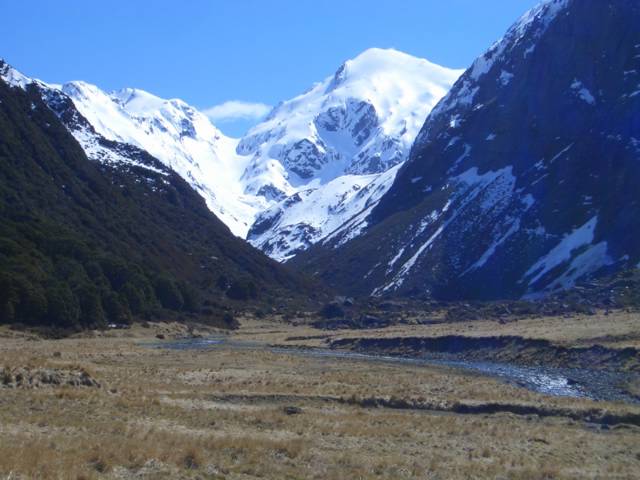
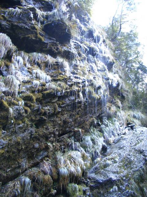
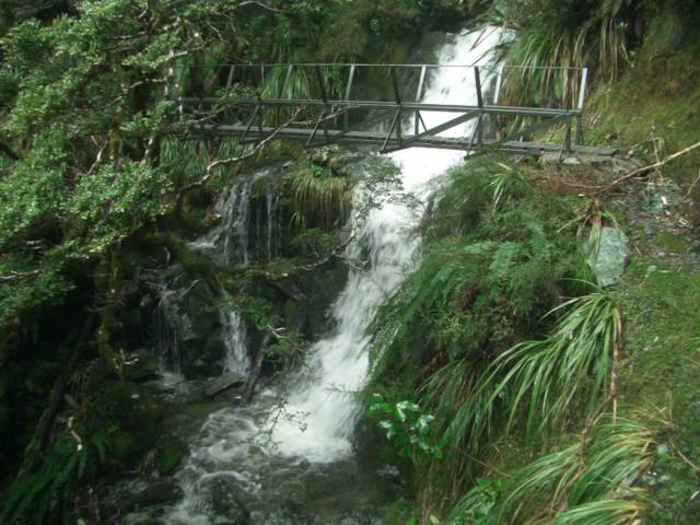
I slept soundly but felt like I couldn’t move my knee in the morning. Of course it just took a while to warm up as I limped around the hut making hot drinks and trying to get warm – it had poured with rain all night so I was psyching myself up to get started again and still kind of debating which way to go. I set off over the Divide in the pouring rain (at least my expensive new rain jacket was getting used), and took the track up to Key Summit and the Alpine Nature Walk. “Great views over Lake Marion” said the sign at the top…it’s a pity I couldn’t see anything past the sign! Over the Divide the track reaches one end of the Routeburn Track, and I planned to hitch a ride up to the Hollyford Track where I could do a couple of days on that, before eventually looping back to the car via Greenstone Track. However, after standing for 20 minutes in the rain at the side of the road, I began to wonder what my options were if I couldn’t hitch a ride back a couple of days later. Without a hut nearby, they were definitely limited. That, combined with ideas to do the other side of the Routeburn, made me head back over the Divide to Howden Hut (and wish I’d just left my pack there a couple of hours earlier!) This time I did leave my pack, and headed up the Routeburn Track to Earland Falls. After thinking I’d reached it 3 times (but thinking I’ll just go a bit further each time), I finally did reach the falls – and watched 80m of crashing water from below.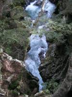
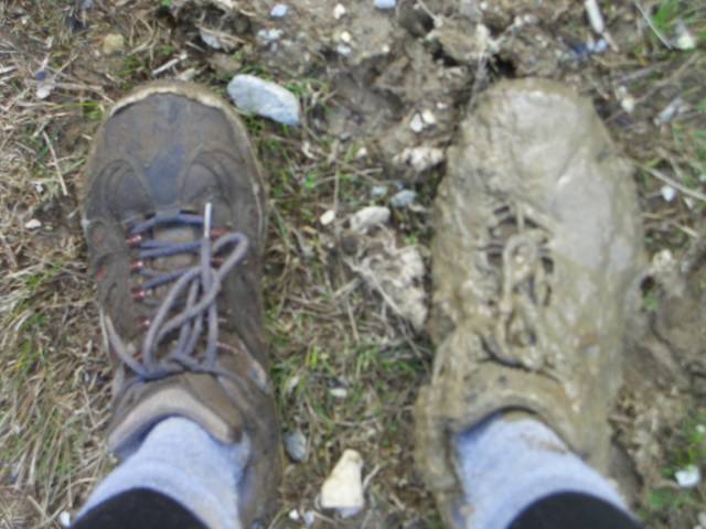
 Beyond this point there wasn’t far I could go – comments in the hut book and signs at DOC had suggested McKenzie Hut wasn’t reachable for snow, and it certainly looked that way above Earland Falls. I headed back down, collected my pack, and followed the track the length of Lake McKerrow to reach McKellar Hut by 4:30pm. It felt like an early finish for me (!) but the next hut was about 4 hours further (which was just as well because I probably would have tried to reach it otherwise, and I was pretty shattered). The weather had cleared up a bit but I was wet and muddy and glad to get dry and warm(er) in the hut. Still no luck with a fire (maybe I just need a lesson in fire-building?!) but it was nice to relax for a while before another early night. Despite passing a few people each day on the track, nobody was in either hut I stayed in at this point.

The next morning the sun was shining again, which warmed me up after starting out in soaking wet shoes (carrying my boots by now, which I’d attempted to wear in both days, lasting about 2 hours before the blisters rudely demanded attention).


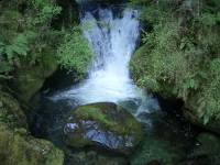
The track alternated between interesting forest and open valley areas, following the Greenstone River back toward its conjunction with the Caples. A short side trip to Greeenstone Hut (a new hut which is in a really pretty and hidden location) for lunch in the sun, before the sandflies told me it was time to get moving again.
 I took another side loop just before the two rivers joined, following Lake Rere Track around to Elfin Bay and then back to the car park. Although slightly further I always have to do the extra bits (!), it was worth it especially in the great weather. Once back at the car I was keen to get to Kinloch and use a phone, just to let someone know I was alive (in case anyone was bothered!) seeing as I hadn’t followed the original plan at all, and I’d been hearing mum’s voice in the back of my head for the last three days. chuckle .

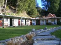
After considering sleeping in the car again, I was convinced otherwise by the appeal of a nice shower and warm bed at Kinloch backpackers. (WEAK, but I’m glad I did!) It was a really nice place, in a beautiful location overlooking the lake and surrounded by mountains. I think free use of the spa pool was a good factor in the decision as well. Accepting the offer of a well-earned beer from these two guys already in the spa, I realised too late that they were about 45 and naked, but then the Kiwis don’t seem to care about much. They’d been enjoying several beers already, and were there for the Glenorchy fishing competition that weekend (although I think having a good laugh rather than doing particularly well was the general idea). After a good shower and great dinner (although I say so myself) I had another great night’s sleep.

 On Saturday morning I drove to the start of the Routeburn Track, and thought I’d see how far up this side of the track I could get! It doesn’t take long to get to the first hut (Routeburn Flats) where I left my pack and crossed the river to do a side track up North Branch Valley.
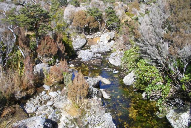
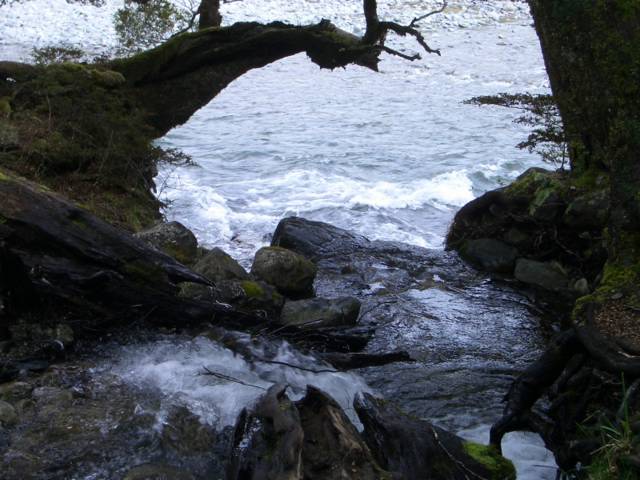
It was a beautiful section along the river to the end of a glacier, although not well marked suggesting few people go off the main track.


Blue skies and sunshine (just one more time!) probably added to the appeal, and the fact that nobody else was around. Unsure whether I’d reached the end of the track or not, I attempted to cross the terminal moraine, an interesting combination of bush-bashing and bouldering which definitely turned into Adventures 101...I’ll leave it at that. Back at the hut I relaxed for about 5 minutes (!) before becoming curious how far past the next hut I could get.

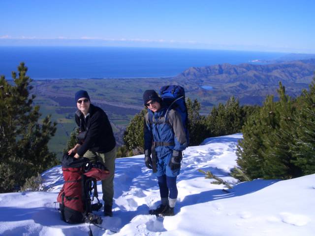
 The track climbs up to Routeburn Falls Hut (which is huge, sleeps 48!) where I was going to spend the night. Another guy (another Gavin!) had similar intentions to explore up past the hut, so it was quite nice to have someone else join me for a while. Just above the Routeburn Falls Hut the track becomes really impressive, made even more so by the glistening snow which was getting deeper by the minute. Tracks were already made which helped considerably, but we were having a laugh as one firm step on the surface was followed by the next sinking waist-deep in snow!


The tracks didn’t extend beyond Harris Lake, and avalanche dangers were posted in the hut so this was as far as we went. The views were incredible though, and it was well worth the hard work through the snow to reach that point.
Back at the hut, there was a big group (about 20) from Dunedin, and one of them had brought a guitar up which made for some fun singing after dinner. Despite the cold, it was almost a relief that nobody could get a fire going here either, because it made me think my attempts the previous nights were less feeble.
It was kind of sad knowing I had to leave on Sunday because it had been a great few days, despite being by myself for most of the time. The thought of a seven-hour drive home wasn’t too appealing either, but after stopping in Cromwell for food and a 1.5L bottle of 7-UP, I had a caffeine high which kept me singing all the way back to Christchurch (well, almost). The Hollyford Track is definitely still on the list though, and will be done sometime!
The overview...

 My own hiking adventure crossing Mt. Aspiring & Fjordland National Parks was brilliant, yet the more tracks I do, the more I realise there are still to do! This week was great fun - hiking Greenstone & Caples, Lake Rere, and the Routeburn as far as possible from both ends. Incredible views, interesting trails, and superb weather for the most part.
See more pics!
I set off on Tuesday morning, heading for Fjordlands with a few maps printed out and a general idea of some tracks which I could do
 (options were limited due to the winter weather which has closed many parts of some tramps). Although I’d planned on going to Te Anau and then probably heading up to the Hollyford Track, I changed my mind after reaching Queenstown and decided to start at the Glenorchy side and work my way over. That way I could check current conditions with DOC Glenorchy in the morning and still be on a track soon afterwards, instead of adding four hours of extra driving into the journey. After sleeping in the car (well, kind of), I signed in my intentions (a bit vague at this point) and drove to Kinloch, a beautiful area across Lake Wakatipu. A rough track leads from there to Greenstone car park where the Greenstone and Caples tracks begin.
 I followed the Caples track to Howden Hut the first day, a fantastic track with loads of variety. I definitely like the open valleys or at least being on the outskirts of a forest following rivers rather than being stuck beneath a bushline all day.
 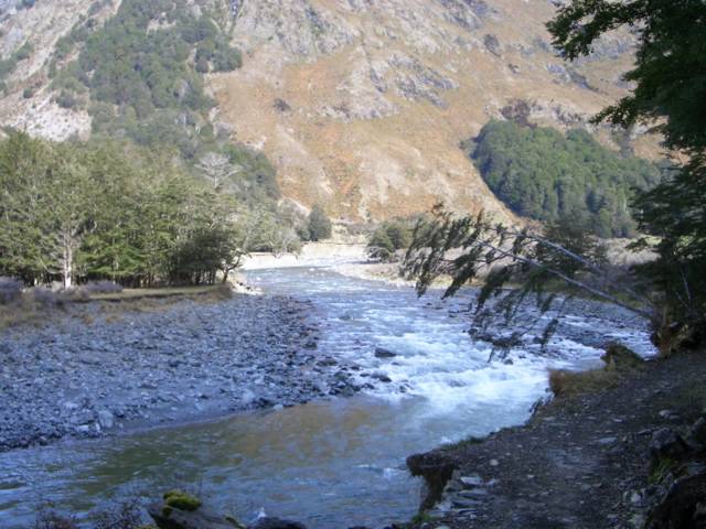 Not to sound like a broken record, but the weather was amazing again, it’s a pity this has to end sometime! I managed to smack my knee on a fallen tree which was kind of painful but keeping moving was the only solution…I was slightly fearful it would stiffen up if I stopped for a rest, and there wasn’t really time for that anyway! After Upper McKellar Hut the track climbs steeply for a while to McKellar Saddle, followed by an extremely sharp and interesting descent, especially with fallen trees and rocks blocking much of the track!


After skirting around the side of Lake McKerrow it ends up joining the Western end of the Routerburn Track at Howden Hut. Unfortunately I couldn’t get a fire going that night because there was hardly any dry firewood or coal in the bucket, but at least it hadn’t rained so I was pretty dry and not too cold.
I slept soundly but felt like I couldn’t move my knee in the morning. Of course it just took a while to warm up as I limped around the hut making hot drinks and trying to get warm – it had poured with rain all night so I was psyching myself up to get started again and still kind of debating which way to go. I set off over the Divide in the pouring rain (at least my expensive new rain jacket was getting used), and took the track up to Key Summit and the Alpine Nature Walk. “Great views over Lake Marion” said the sign at the top…it’s a pity I couldn’t see anything past the sign! Over the Divide the track reaches one end of the Routeburn Track, and I planned to hitch a ride up to the Hollyford Track where I could do a couple of days on that, before eventually looping back to the car via Greenstone Track. However, after standing for 20 minutes in the rain at the side of the road, I began to wonder what my options were if I couldn’t hitch a ride back a couple of days later. Without a hut nearby, they were definitely limited. That, combined with ideas to do the other side of the Routeburn, made me head back over the Divide to Howden Hut (and wish I’d just left my pack there a couple of hours earlier!) This time I did leave my pack, and headed up the Routeburn Track to Earland Falls. After thinking I’d reached it 3 times (but thinking I’ll just go a bit further each time), I finally did reach the falls – and watched 80m of crashing water from below.


 Beyond this point there wasn’t far I could go – comments in the hut book and signs at DOC had suggested McKenzie Hut wasn’t reachable for snow, and it certainly looked that way above Earland Falls. I headed back down, collected my pack, and followed the track the length of Lake McKerrow to reach McKellar Hut by 4:30pm. It felt like an early finish for me (!) but the next hut was about 4 hours further (which was just as well because I probably would have tried to reach it otherwise, and I was pretty shattered). The weather had cleared up a bit but I was wet and muddy and glad to get dry and warm(er) in the hut. Still no luck with a fire (maybe I just need a lesson in fire-building?!) but it was nice to relax for a while before another early night. Despite passing a few people each day on the track, nobody was in either hut I stayed in at this point.
The next morning the sun was shining again, which warmed me up after starting out in soaking wet shoes (carrying my boots by now, which I’d attempted to wear in both days, lasting about 2 hours before the blisters rudely demanded attention).

The track alternated between interesting forest and open valley areas, following the Greenstone River back toward its conjunction with the Caples. A short side trip to Greeenstone Hut (a new hut which is in a really pretty and hidden location) for lunch in the sun, before the sandflies told me it was time to get moving again.
 I took another side loop just before the two rivers joined, following Lake Rere Track around to Elfin Bay and then back to the car park. Although slightly further I always have to do the extra bits (!), it was worth it especially in the great weather. Once back at the car I was keen to get to Kinloch and use a phone, just to let someone know I was alive (in case anyone was bothered!) seeing as I hadn’t followed the original plan at all, and I’d been hearing mum’s voice in the back of my head for the last three days. chuckle .


After considering sleeping in the car again, I was convinced otherwise by the appeal of a nice shower and warm bed at Kinloch backpackers. (WEAK, but I’m glad I did!) It was a really nice place, in a beautiful location overlooking the lake and surrounded by mountains. I think free use of the spa pool was a good factor in the decision as well. Accepting the offer of a well-earned beer from these two guys already in the spa, I realised too late that they were about 45 and naked, but then the Kiwis don’t seem to care about much. They’d been enjoying several beers already, and were there for the Glenorchy fishing competition that weekend (although I think having a good laugh rather than doing particularly well was the general idea). After a good shower and great dinner (although I say so myself) I had another great night’s sleep.

 On Saturday morning I drove to the start of the Routeburn Track, and thought I’d see how far up this side of the track I could get! It doesn’t take long to get to the first hut (Routeburn Flats) where I left my pack and crossed the river to do a side track up North Branch Valley.
It was a beautiful section along the river to the end of a glacier, although not well marked suggesting few people go off the main track.


Blue skies and sunshine (just one more time!) probably added to the appeal, and the fact that nobody else was around. Unsure whether I’d reached the end of the track or not, I attempted to cross the terminal moraine, an interesting combination of bush-bashing and bouldering which definitely turned into Adventures 101...I’ll leave it at that. Back at the hut I relaxed for about 5 minutes (!) before becoming curious how far past the next hut I could get.
 The track climbs up to Routeburn Falls Hut (which is huge, sleeps 48!) where I was going to spend the night. Another guy (another Gavin!) had similar intentions to explore up past the hut, so it was quite nice to have someone else join me for a while. Just above the Routeburn Falls Hut the track becomes really impressive, made even more so by the glistening snow which was getting deeper by the minute. Tracks were already made which helped considerably, but we were having a laugh as one firm step on the surface was followed by the next sinking waist-deep in snow!


The tracks didn’t extend beyond Harris Lake, and avalanche dangers were posted in the hut so this was as far as we went. The views were incredible though, and it was well worth the hard work through the snow to reach that point.
Back at the hut, there was a big group (about 20) from Dunedin, and one of them had brought a guitar up which made for some fun singing after dinner. Despite the cold, it was almost a relief that nobody could get a fire going here either, because it made me think my attempts the previous nights were less feeble.

It was kind of sad knowing I had to leave on Sunday because it had been a great few days, despite being by myself for most of the time. The thought of a seven-hour drive home wasn’t too appealing either, but after stopping in Cromwell for food and a 1.5L bottle of 7-UP, I had a caffeine high which kept me singing all the way back to Christchurch (well, almost). The Hollyford Track is definitely still on the list though, and will be done sometime!
The overview...

 My own hiking adventure crossing Mt. Aspiring & Fjordland National Parks was brilliant, yet the more tracks I do, the more I realise there are still to do! This week was great fun - hiking Greenstone & Caples, Lake Rere, and the Routeburn as far as possible from both ends. Incredible views, interesting trails, and superb weather for the most part.
See more pics!
posted by Mhairi
2 comments
![]()