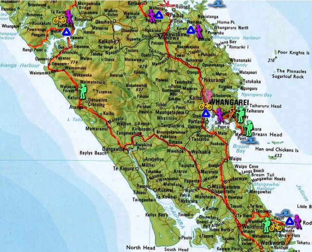
Northlands
Here's the full story...!
Jan 18th/19th: Goat Island Scenic Reserve
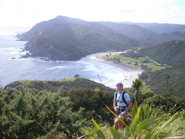
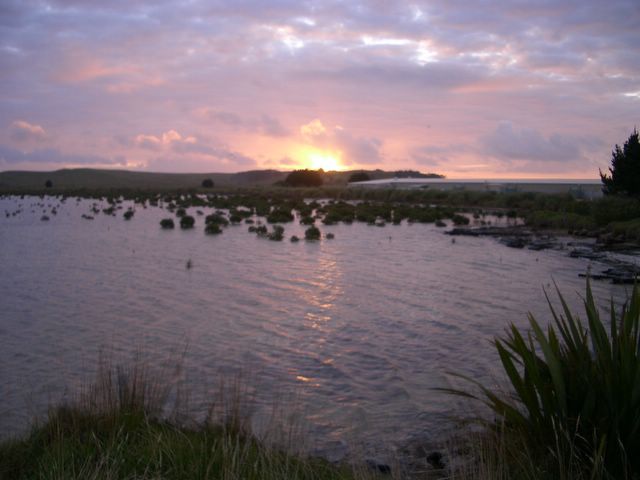
Marcel had found a nice spot to camp overlooking Leigh Bay, and we didn’t even need the tent – it was a perfect night with clear skies and stars everywhere, and the weather has been great ever since. Sunrise over Leigh Bay the next morning was great to see, and then we headed off on a bike ride and hike up to Mt.
Before leaving to head north, we explored Ti Point, where I’d been told there was great climbing, and after walking around the headland for a while we found the spot! Unfortunately without a rope there wasn’t a lot we could do, but we had some fun bouldering and got some great pictures anyway – a good spot to remember. After stopping at Pakiri Beach for a swim (it took a while for me to get in but felt really refreshing), we continued north, leaving my car at Wellsford and continuing in Marcel’s Mitsubishi. I made him take a slight detour through Waipu, purely because my map named this as a Scottish Highlander Settlement (it wasn’t really that exciting but I felt a sense of duty).
Jan 20th: Whangarei
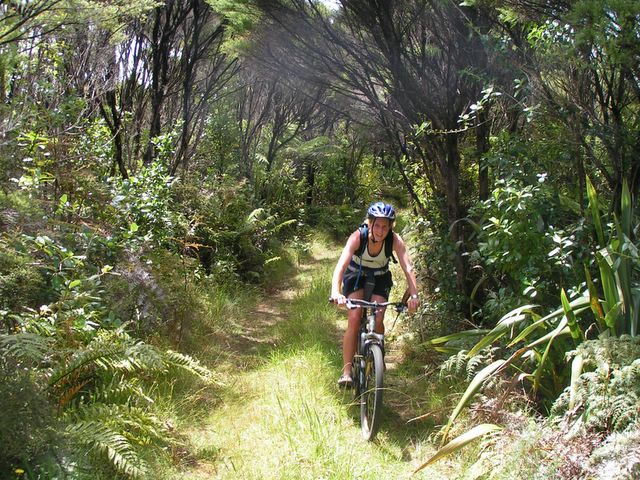
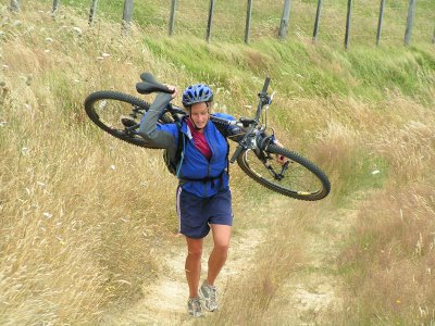
We found a campsite on the outskirts for the night and had a walk into town, which was unbelievably quiet with hardly anything open. Our activities for the next day started with a bike ride to Onerahi, a run along the Old Waimahanga Walkway, and then biking back to the campground for a shower before exploring Whangarei Heads. We drove along the scenic coastal route and hiked up Mt. Manaia which had absoloutely superb panoramic views of the surrounding area. Got some great pics on the top of us climbing on the rocks – we look like total pros but I think the photo taking might have more to do with that than actual climbing ability. Continuing to Urquharts Bay we walked to Smugglers Cove – quiet and unspoilt this was a perfect spot for relaxing and trying to improve the tan. Walking back on the cliffs provided more amazing views – the entire Northlands area has been incredible so far. On the way out of town we stopped at Whangarei Falls, also quite impressive (and so was devouring a 2-litre tub of Caramel Swirl ice-cream between us).
Jan 21st/22nd: Paihia
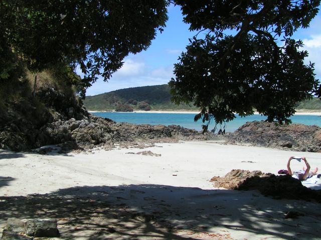
We camped somewhere just south of here but it wasn’t a great spot, apart from the comfy metre-deep vegetation we pitched the tent in. Tourist Day in Paihia!! We took a sailing boat out to the Bay of Islands, and the highlight was definitely seeing loads of dolphins – they came so close to the boat and were jumping in and out of the water…beautiful to watch. We stopped at Urupukapuka Island for lunch, and had a small walk up to the ridge for views, plus a short snorkel in the bay area. The BBQ lunch was great, and sailing back we saw more dolphins as well as relaxing reading on the back of the boat. In the evening we had a walk through Waitangi Reserve, seeing the Treaty House and the Marae where the Waitangi Treaty was signed on February 6th 1840, putting New Zealand under British rule. We camped at Twin Beach campsite, right beside Haruru Falls.
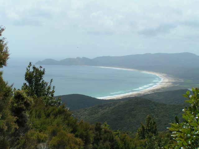
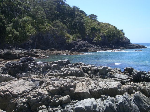
Bay of Islands (cont) We had a great run along the Haruru Falls Track the next morning, following the river back to Waitangi and then returning to the Falls and paddling through the water above them back to our tent! We rented kayaks for a couple of hours and paddled across the Bay from Paihia/Waitangi to a bay just north of Russell. This was easy work for Marcel but quite the effort for me. On to Kerikeri and we walked to Rainbow Falls (waterfalls are quite the attraction at the moment J ) before visiting the much anticipated but disappointingly tiny chocolate factory “Makana”. Continuing North we took the coastal road via Matauri Bay and climbed the hill to the Rainbow Warrior Dive Site Memorial. The views were AMAZING from here - cliffs and beaches looking superb in every direction. We found a tremendous camping spot on the beach just north of Te Ngaere, and there was a firework display put on especially for us!
Jan 23rd: Te Ngaere --> North!
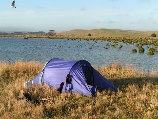
After a run along the coastal road in the morning, we both attempted to test our swimming skills in the sea at Te Ngaere. We achieved our 1st goal, across the bay but not really sure how far that was. Continuing North around the coast we stopped briefly at Cable Bay and then headed out to the Karikari Peninsula to Maitai Bay – definitely worth a visit. Swimming challenge #2 – across the bay here, which we later worked out to be just under 1km – we thought it was quite a good effort anyway. After topping up the tan some more we continued to Kataia to get some information for the Cape Reinga area. Marcel’s car wasn’t always in the mood to start again today so I was employed to push - training for the ultra marathon (not really) which takes place on the 90-mile beach (which is actually 90km) in March. Another 2-litre tub of ice-cream had to be purchased (our excuse is its actually cheaper than buying individual ones) – strawberry ripple which I liked much better so I think had my fair share this time. After driving out to Henderson Bay (which looked amazing but no camping allowed) we found another great camp spot just north of Paua.
Jan 24th/25th: Cape Reinga
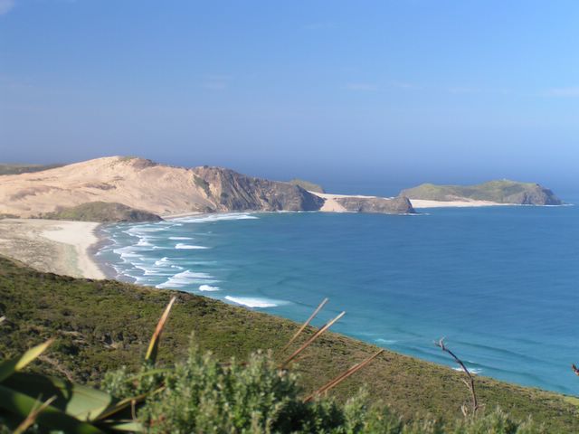
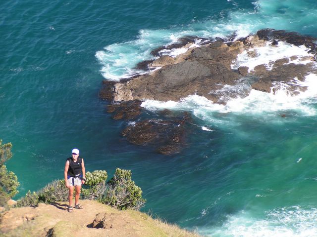
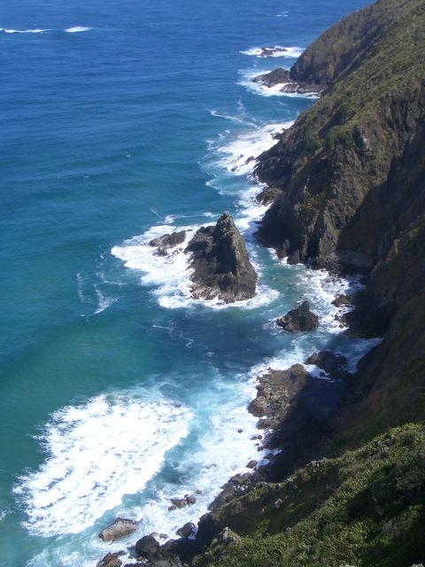
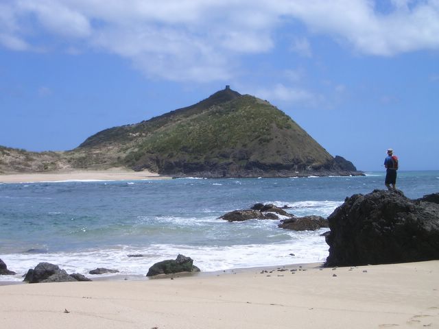
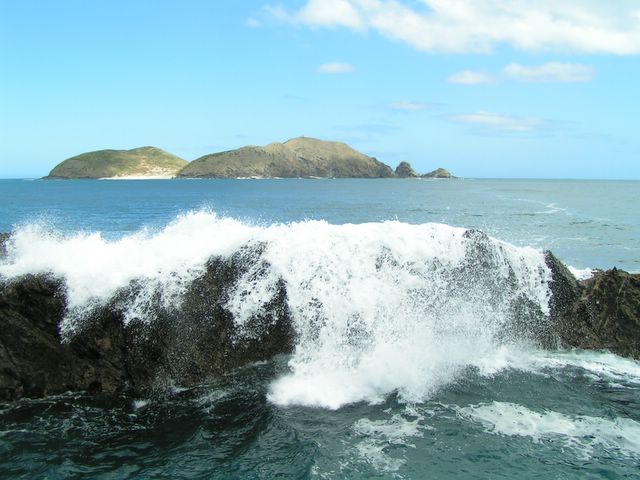
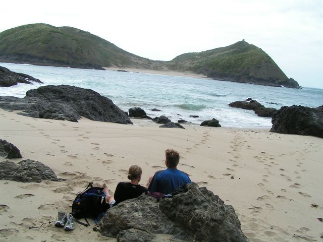
Cape Reinga is an amazing spot – the northernmost accessible point in New Zealand – incredible views and total calmness all around. After a short walk to the lighthouse on the ‘point’ of the cape, we started the Coastal Walkway south towards Cape Maria van Diemen. We had set ourselves another swimming challenge for the day, across to Motuopao Island from Cape Maria van Diemen. It certainly seemed manageable - we had guessed about 500m or so - but in retrospect it was possibly the stupidest thing I have ever tried to do. The waves were bigger than we had anticipated, the crosswind more of a factor, and the tidal current far larger than we could imagine. On the way across we both got a real scare, but luckily managed to land on a beach about 200m east of the one we were aiming for. I was literally washed ashore by a massive wave and thankfully we had both managed to avoid the rocky cliffs. We really didn’t have a lot of choice at this point (another reason it was a bad idea), but we decided our best chance of making it back was to wait until low tide, when we hoped the current would be least powerful, and the waves at their smallest. That was not for 2 ½ hours, so we lay on the sand (to keep warm…the water had been pretty cold) and covered ourselves as best we could to prevent sunburn. The waves did seem to lessen in height, and the wind dropped slightly (or maybe we were just being positive), and by 3:30 I was feeling fairly confident the return journey would be okay, although I certainly wasn’t looking forward to it. We picked our point to aim for, and agreed to stay close together and keep assessing the situation. Halfway across it felt like we were cruising, and perfectly on target for the beach. However, the next time I lifted my head I had been swept far right and the waves suddenly seemed to be huge. I couldn’t see Marcel anymore, and I definitely felt a rush of panic. I turned myself 45 degrees left and swam as fast as I could against the current, but it didn’t seem to make much difference. I spotted Marcel further ahead in the same situation, but although we were getting closer to land, the only hope we had was reaching the rocks before we were swept past the headland…we weren’t anywhere close to our target beach. I was kicking and pulling as hard as I could, but inside my mind was racing with thoughts that we weren’t going to make it. I swallowed a huge gulp of seawater as I got pushed under again by another wave, but after a couple of minutes I saw Marcel scrambling up on the rocks and it gave me a huge burst of relief along with a small sense of belief that I could actually make it. I suddenly got pushed forcefully in the direction of the rocks, but I couldn’t care less if I got hurt getting out, I just wanted to reach the shore. Fortunately the area that we got swept to was covered in large clumps of seaweed and as I reached it Marcel was shouting to grab onto the grass. I managed to haul myself out before the next huge wave came and we scrambled up the rocks to a safe part. MAJOR sigh of relief – we were both shaking and it wasn’t just from the cold water. I think we both have way more respect for the power of an ocean from that experience, and the swimming challenges might take a backseat for a while.
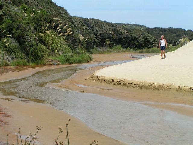
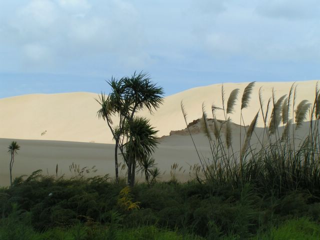
Despite the frightening experience, we still thought the whole area was incredible, and well worth a visit! Walking back towards Cape Reinga (we stuck to the track this time instead of taking the cliffs), we crossed large sand dunes which contrasted sharply with the grassy hills further ahead, as well as the rocky cliffs and crashing waves below. It was really impressive to see such dramatic changes in such a small area. We camped at the DOC site at Tapotupotu Bay, just east of Cape Reinga, which only had cold showers but it felt fantastic! In the morning we ran (well, the downhill sections anyway!) the section of the Coastal Walkway via Sandy Bay to Cape Reinga and back. Then we drove back to the Pandora Track turnoff and biked from here to the Te Paki lookout for views over Spirits Bay and towards Hooper Point.
Our next challenge was to drive the 90-mile beach (which is actually only 90 km) from north to south. We managed to get passed the Te Paki stream and amazing sand dunes onto the beach (which was supposedly the hardest part) but then we got stuck in the sand. A 4WD towed us out and we had to take the highway 1 back again instead – maybe we are setting our sights too high with the challenges.
Heading down the West Coast of the Northlands next, we camped at The Tree House in Kohukohu, which was a brilliant place and well worth staying at – really well set up in a gorgeous area with very friendly owners. Nice and relaxing!
The overview...

 Northlands was absolutely "tremendous"! Our 8 days spent travelling around this area was incredible...there was no rush, and yet we did and saw an unbelievable amount, and loved it all. The weather was amazing, the beaches and views were spectacular - I've tried to think of the highlights, but the whole area was so special its hard to choose.
18/1 - 27/1
See more pics!
Jan 18th/19th: Goat Island Scenic Reserve
Marcel had found a nice spot to camp overlooking Leigh Bay, and we didn’t even need the tent – it was a perfect night with clear skies and stars everywhere, and the weather has been great ever since. Sunrise over Leigh Bay the next morning was great to see, and then we headed off on a bike ride and hike up to Mt.
Before leaving to head north, we explored Ti Point, where I’d been told there was great climbing, and after walking around the headland for a while we found the spot! Unfortunately without a rope there wasn’t a lot we could do, but we had some fun bouldering and got some great pictures anyway – a good spot to remember. After stopping at Pakiri Beach for a swim (it took a while for me to get in but felt really refreshing), we continued north, leaving my car at Wellsford and continuing in Marcel’s Mitsubishi. I made him take a slight detour through Waipu, purely because my map named this as a Scottish Highlander Settlement (it wasn’t really that exciting but I felt a sense of duty).
Jan 20th: Whangarei
We found a campsite on the outskirts for the night and had a walk into town, which was unbelievably quiet with hardly anything open. Our activities for the next day started with a bike ride to Onerahi, a run along the Old Waimahanga Walkway, and then biking back to the campground for a shower before exploring Whangarei Heads. We drove along the scenic coastal route and hiked up Mt. Manaia which had absoloutely superb panoramic views of the surrounding area. Got some great pics on the top of us climbing on the rocks – we look like total pros but I think the photo taking might have more to do with that than actual climbing ability. Continuing to Urquharts Bay we walked to Smugglers Cove – quiet and unspoilt this was a perfect spot for relaxing and trying to improve the tan. Walking back on the cliffs provided more amazing views – the entire Northlands area has been incredible so far. On the way out of town we stopped at Whangarei Falls, also quite impressive (and so was devouring a 2-litre tub of Caramel Swirl ice-cream between us).
Jan 21st/22nd: Paihia
We camped somewhere just south of here but it wasn’t a great spot, apart from the comfy metre-deep vegetation we pitched the tent in. Tourist Day in Paihia!! We took a sailing boat out to the Bay of Islands, and the highlight was definitely seeing loads of dolphins – they came so close to the boat and were jumping in and out of the water…beautiful to watch. We stopped at Urupukapuka Island for lunch, and had a small walk up to the ridge for views, plus a short snorkel in the bay area. The BBQ lunch was great, and sailing back we saw more dolphins as well as relaxing reading on the back of the boat. In the evening we had a walk through Waitangi Reserve, seeing the Treaty House and the Marae where the Waitangi Treaty was signed on February 6th 1840, putting New Zealand under British rule. We camped at Twin Beach campsite, right beside Haruru Falls.
Bay of Islands (cont) We had a great run along the Haruru Falls Track the next morning, following the river back to Waitangi and then returning to the Falls and paddling through the water above them back to our tent! We rented kayaks for a couple of hours and paddled across the Bay from Paihia/Waitangi to a bay just north of Russell. This was easy work for Marcel but quite the effort for me. On to Kerikeri and we walked to Rainbow Falls (waterfalls are quite the attraction at the moment J ) before visiting the much anticipated but disappointingly tiny chocolate factory “Makana”. Continuing North we took the coastal road via Matauri Bay and climbed the hill to the Rainbow Warrior Dive Site Memorial. The views were AMAZING from here - cliffs and beaches looking superb in every direction. We found a tremendous camping spot on the beach just north of Te Ngaere, and there was a firework display put on especially for us!
Jan 23rd: Te Ngaere --> North!
After a run along the coastal road in the morning, we both attempted to test our swimming skills in the sea at Te Ngaere. We achieved our 1st goal, across the bay but not really sure how far that was. Continuing North around the coast we stopped briefly at Cable Bay and then headed out to the Karikari Peninsula to Maitai Bay – definitely worth a visit. Swimming challenge #2 – across the bay here, which we later worked out to be just under 1km – we thought it was quite a good effort anyway. After topping up the tan some more we continued to Kataia to get some information for the Cape Reinga area. Marcel’s car wasn’t always in the mood to start again today so I was employed to push - training for the ultra marathon (not really) which takes place on the 90-mile beach (which is actually 90km) in March. Another 2-litre tub of ice-cream had to be purchased (our excuse is its actually cheaper than buying individual ones) – strawberry ripple which I liked much better so I think had my fair share this time. After driving out to Henderson Bay (which looked amazing but no camping allowed) we found another great camp spot just north of Paua.
Jan 24th/25th: Cape Reinga
Cape Reinga is an amazing spot – the northernmost accessible point in New Zealand – incredible views and total calmness all around. After a short walk to the lighthouse on the ‘point’ of the cape, we started the Coastal Walkway south towards Cape Maria van Diemen. We had set ourselves another swimming challenge for the day, across to Motuopao Island from Cape Maria van Diemen. It certainly seemed manageable - we had guessed about 500m or so - but in retrospect it was possibly the stupidest thing I have ever tried to do. The waves were bigger than we had anticipated, the crosswind more of a factor, and the tidal current far larger than we could imagine. On the way across we both got a real scare, but luckily managed to land on a beach about 200m east of the one we were aiming for. I was literally washed ashore by a massive wave and thankfully we had both managed to avoid the rocky cliffs. We really didn’t have a lot of choice at this point (another reason it was a bad idea), but we decided our best chance of making it back was to wait until low tide, when we hoped the current would be least powerful, and the waves at their smallest. That was not for 2 ½ hours, so we lay on the sand (to keep warm…the water had been pretty cold) and covered ourselves as best we could to prevent sunburn. The waves did seem to lessen in height, and the wind dropped slightly (or maybe we were just being positive), and by 3:30 I was feeling fairly confident the return journey would be okay, although I certainly wasn’t looking forward to it. We picked our point to aim for, and agreed to stay close together and keep assessing the situation. Halfway across it felt like we were cruising, and perfectly on target for the beach. However, the next time I lifted my head I had been swept far right and the waves suddenly seemed to be huge. I couldn’t see Marcel anymore, and I definitely felt a rush of panic. I turned myself 45 degrees left and swam as fast as I could against the current, but it didn’t seem to make much difference. I spotted Marcel further ahead in the same situation, but although we were getting closer to land, the only hope we had was reaching the rocks before we were swept past the headland…we weren’t anywhere close to our target beach. I was kicking and pulling as hard as I could, but inside my mind was racing with thoughts that we weren’t going to make it. I swallowed a huge gulp of seawater as I got pushed under again by another wave, but after a couple of minutes I saw Marcel scrambling up on the rocks and it gave me a huge burst of relief along with a small sense of belief that I could actually make it. I suddenly got pushed forcefully in the direction of the rocks, but I couldn’t care less if I got hurt getting out, I just wanted to reach the shore. Fortunately the area that we got swept to was covered in large clumps of seaweed and as I reached it Marcel was shouting to grab onto the grass. I managed to haul myself out before the next huge wave came and we scrambled up the rocks to a safe part. MAJOR sigh of relief – we were both shaking and it wasn’t just from the cold water. I think we both have way more respect for the power of an ocean from that experience, and the swimming challenges might take a backseat for a while.
Despite the frightening experience, we still thought the whole area was incredible, and well worth a visit! Walking back towards Cape Reinga (we stuck to the track this time instead of taking the cliffs), we crossed large sand dunes which contrasted sharply with the grassy hills further ahead, as well as the rocky cliffs and crashing waves below. It was really impressive to see such dramatic changes in such a small area. We camped at the DOC site at Tapotupotu Bay, just east of Cape Reinga, which only had cold showers but it felt fantastic! In the morning we ran (well, the downhill sections anyway!) the section of the Coastal Walkway via Sandy Bay to Cape Reinga and back. Then we drove back to the Pandora Track turnoff and biked from here to the Te Paki lookout for views over Spirits Bay and towards Hooper Point.
Our next challenge was to drive the 90-mile beach (which is actually only 90 km) from north to south. We managed to get passed the Te Paki stream and amazing sand dunes onto the beach (which was supposedly the hardest part) but then we got stuck in the sand. A 4WD towed us out and we had to take the highway 1 back again instead – maybe we are setting our sights too high with the challenges.
Heading down the West Coast of the Northlands next, we camped at The Tree House in Kohukohu, which was a brilliant place and well worth staying at – really well set up in a gorgeous area with very friendly owners. Nice and relaxing!
The overview...
 Northlands was absolutely "tremendous"! Our 8 days spent travelling around this area was incredible...there was no rush, and yet we did and saw an unbelievable amount, and loved it all. The weather was amazing, the beaches and views were spectacular - I've tried to think of the highlights, but the whole area was so special its hard to choose.
 18/1 - 27/1
See more pics!
posted by Mhairi
0 comments
![]()